

Journal of System Simulation ›› 2026, Vol. 38 ›› Issue (10): 2872-2886.doi: 10.16182/j.issn1004731x.joss.26-0536
• Intelligent Optimization Algorithms and Autonomous Decision?Making • Previous Articles Next Articles
Li Dequan1,2, Jiang Jiahao2
Received:2026-06-01
Revised:2026-06-18
Online:2026-10-31
Published:2026-10-20
CLC Number:
Li Dequan, Jiang Jiahao. Multimodal Perception-based Trajectory Planning Method for UAVs in Forest Environments[J]. Journal of System Simulation, 2026, 38(10): 2872-2886.
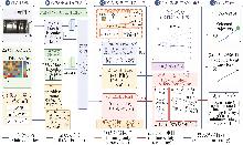
Fig. 1
System architecture of proposed method
Table 1
Trajectory time horizons at different test speeds
| 测试速度/(m/s) | 轨迹时域/s |
|---|---|
| 2 | 5.00 |
| 4 | 2.50 |
| 6 | 1.67 |
| 8 | 1.25 |
| 10 | 1.00 |
Table 2
Network architecture configuration
| 模块 | 输入/通道 | 实现 | 输出 |
|---|---|---|---|
| 深度图分支 | 1×96×160 | 单通道ResNet18,输出层1×1卷积到64维 | 64维深度特征 |
| OccMap分支 | 1×100×100 | 插值到96×160后输入单通道ResNet18,输出64维 | 64维占据特征 |
| 状态变换 | v 、 a 、 g | 归一化后变换到各primitive frame | 9维候选状态特征 |
| 融合与共享头 | 137 | 1×1 Conv:137→256→256,ReLU激活 | 候选级融合特征 |
| 输出头 | 256通道 | 轨迹头9维;代价头Softplus;风险头Sigmoid | p / v / a 、代价、风险概率 |
| 模型规模 | — | 完整模型参数量约22.52×10⁶ | 训练/推理共用 |
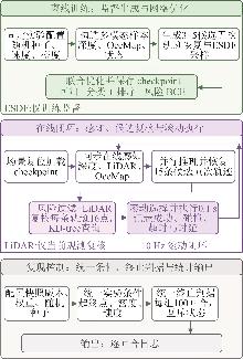
Fig. 2
Training and closed-loop testing procedure
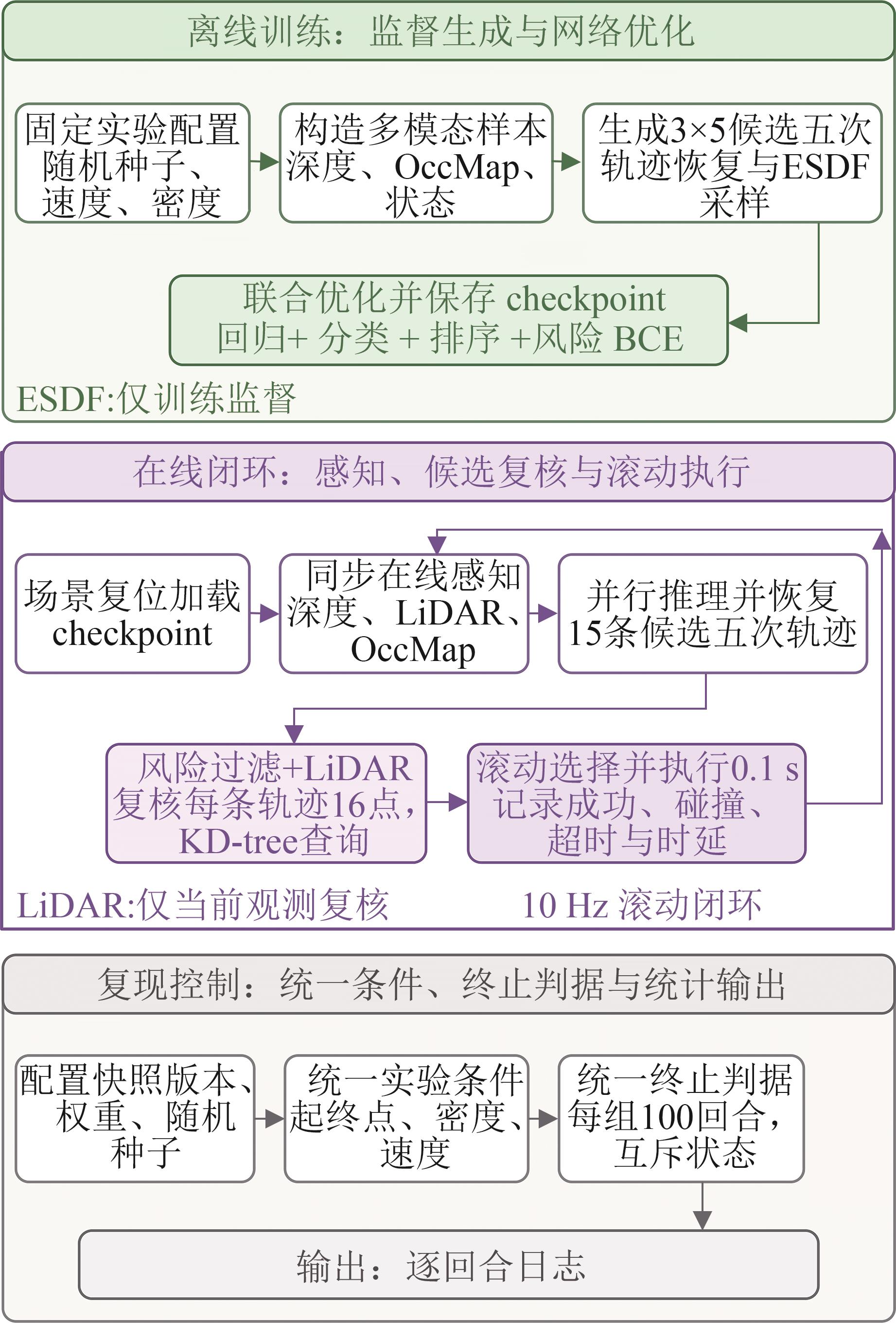
Table 3
Overall performance comparison
| 方法 | 障碍密度/(株/m²) | 成功率/%(95%CI) | 碰撞率/%(95%CI) | 超时率/% | 最小安全距离/m | 平均规划时延/ms | 平滑性 |
|---|---|---|---|---|---|---|---|
| Baseline | 0.033 | 52[42.32,61.54] | 9[4.81,16.23] | 39 | 0.326±0.086 | 11.35 | 109.53 |
| E2E-DepthNet | 45[35.61,54.76] | 17[10.89,25.55] | 38 | 0.299±0.107 | 8.49 | 127.92 | |
| MPC-Replan | 64[54.24,72.73] | 5[2.15,11.18] | 31 | 0.388±0.081 | 31.83 | 106.98 | |
| Async-E2E-LiDAR | 72[62.51,79.86] | 7[3.43,13.75] | 21 | 0.218±0.035 | 5.90 | 138.11 | |
| Ours | 81[72.22,87.49] | 2[0.55,7.00] | 17 | 0.448±0.078 | 20.81 | 114.30 | |
| Baseline | 0.050 | 45[35.61,54.76] | 16[10.10,24.42] | 39 | 0.304±0.110 | 13.77 | 131.23 |
| E2E-DepthNet | 37[28.18,46.78] | 18[11.70,26.67] | 45 | 0.293±0.114 | 11.03 | 125.90 | |
| MPC-Replan | 49[39.42,58.65] | 9[4.81,16.23] | 42 | 0.327±0.081 | 34.32 | 107.31 | |
| Async-E2E-LiDAR | 60[50.20,69.06] | 12[7.00,19.81] | 28 | 0.149±0.028 | 6.30 | 151.80 | |
| Ours | 57[47.22,66.27] | 5[2.15,11.18] | 38 | 0.364±0.079 | 23.27 | 101.75 |
Fig. 3
Visualization of closed-loop trajectories in representative forest obstacle scene
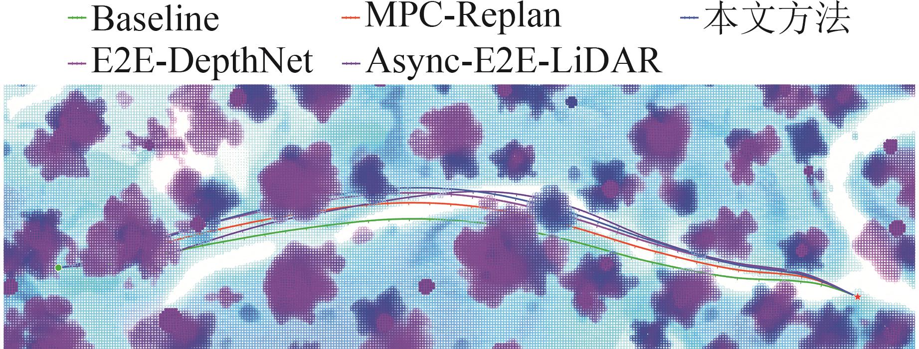
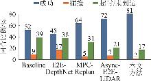
Fig. 4
Closed-loop episode status statistics in low-density scenes
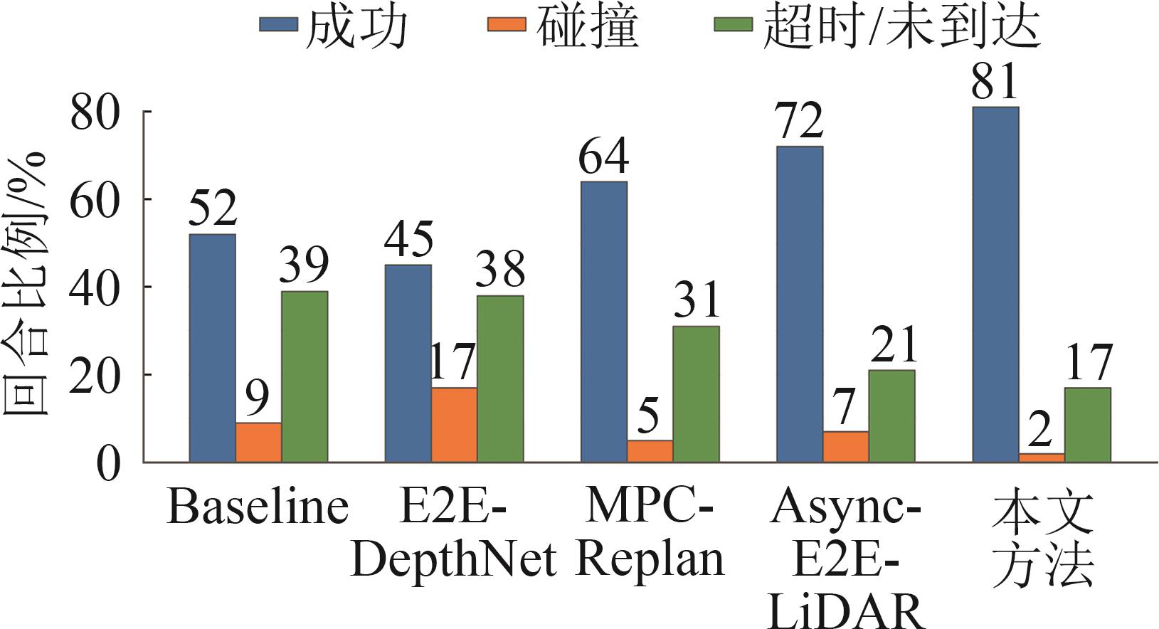
Fig. 5
Closed-loop episode status statistics in high-density scenes
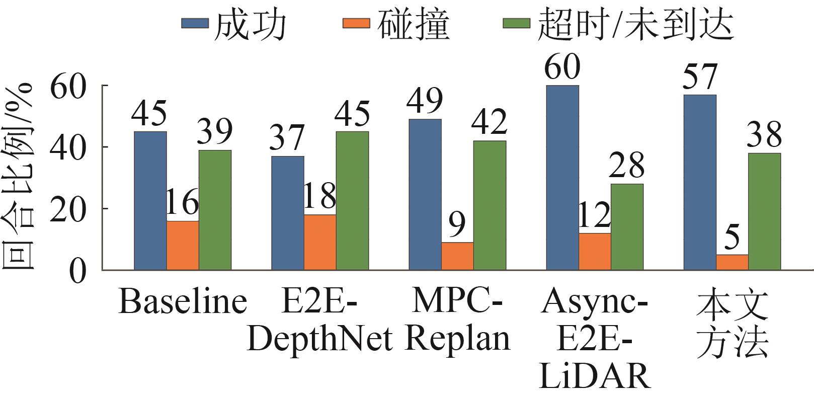
Fig. 6
Success rate versus flight speed in low-density scenes
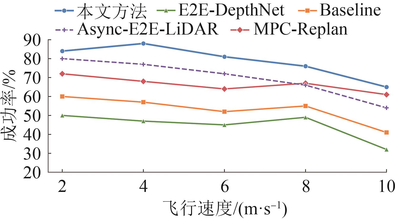
Fig. 7
Success rate versus flight speed in high-density scenes
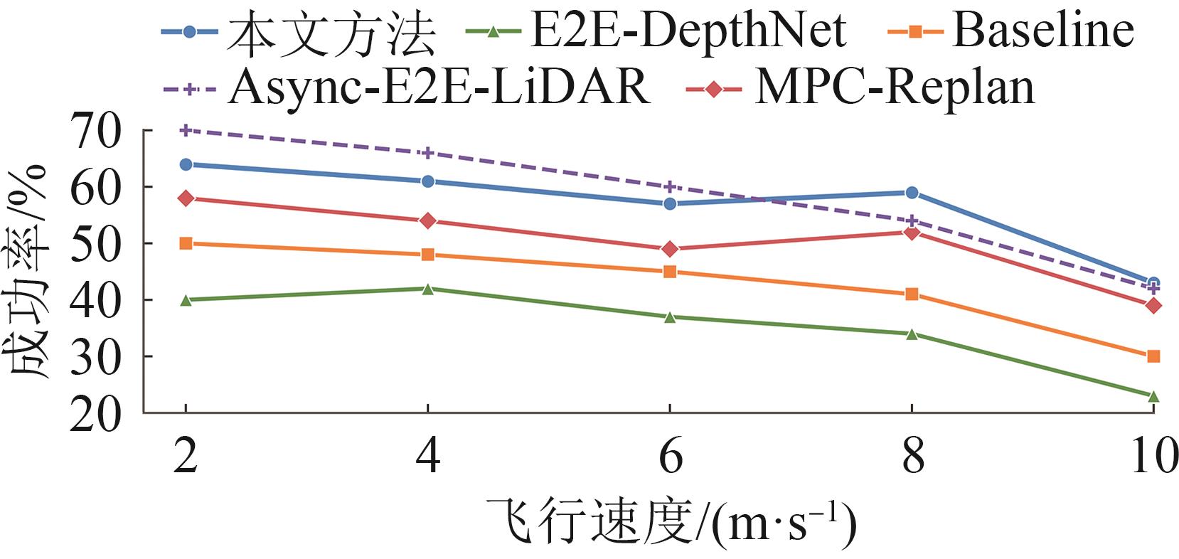
Fig. 8
Success rate heatmap for low- and high-density scenes
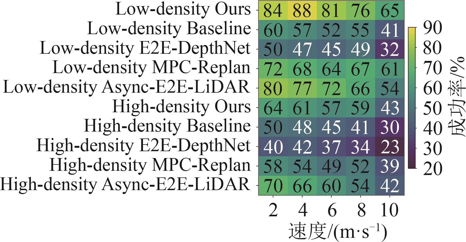
Table 4
Ablation results for main modules
| 配置 | 模块组成 | 密度/(株/m²) | 成功率/% (95%CI) | 碰撞率/% (95%CI) | 超时率/% | 最小安全距离/m |
|---|---|---|---|---|---|---|
| A0 | Depth | 0.033 | 60[50.20,69.06] | 14[8.53,22.14] | 26 | 0.309±0.101 |
| A1 | Depth+Rank | 52[42.32,61.54] | 22[15.00,31.07] | 26 | 0.293±0.120 | |
| A2 | A1+OccMap | 54[44.26,63.44] | 14[8.53,22.14] | 32 | 0.322±0.104 | |
| A3 | A2+Collision Head | 71[61.46,78.99] | 8[4.11,15.00] | 21 | 0.358±0.094 | |
| A4 | A3+LiDAR Rerank | 81[72.22,87.49] | 2[0.55,7.00] | 17 | 0.448±0.078 | |
| A0 | Depth | 0.050 | 43[33.73,52.78] | 19[12.51,27.78] | 38 | 0.297±0.126 |
| A1 | Depth+Rank | 40[30.94,49.80] | 25[17.55,34.30] | 35 | 0.276±0.125 | |
| A2 | A1+OccMap | 51[41.35,60.58] | 15[9.31,23.28] | 34 | 0.304±0.103 | |
| A3 | A2+Collision Head | 53[43.29,62.49] | 13[7.76,20.98] | 34 | 0.312±0.095 | |
| A4 | A3+LiDAR Rerank | 57[47.22,66.27] | 5[2.15,11.18] | 38 | 0.364±0.079 |
| [1] | 张峰玲, 童红卫, 黄天来, 等. 基于混合遗传算法的无人机森林防火巡护路径研究[J]. 浙江林业科技, 2024, 44(5): 132-139. |
| Zhang Fengling, Tong Hongwei, Huang Tianlai, et al. Research on UAV Forest Fire Prevention Patrol Path Based on Hybrid Genetic Algorithm[J]. Journal of Zhejiang Forestry Science and Technology, 2024, 44(5): 132-139. | |
| [2] | 张彪, 康峰, 许舒婷. 基于改进RRT与GA的多目标路径规划-以无人机林区巡检为例[J]. 北京林业大学学报, 2025, 47(4): 129-141. |
| Zhang Biao, Kang Feng, Xu Shuting. Multi-objective Path Planning Based on Improved RRT and GA: Taking UAV Forest Inspection as an Example[J]. Journal of Beijing Forestry University, 2025, 47(4): 129-141. | |
| [3] | Zhou Yuquan, Yan Li, Han Yaxi, et al. A Survey on the Key Technologies of UAV Motion Planning[J]. Drones, 2025, 9(3): 194. |
| [4] | 胡克, 孙洪飞. 未知混动态环境下多无人机轨迹规划[J]. 智能系统学报, 2025, 20(2): 445-456. |
| Hu Ke, Sun Hongfei. Trajectory Planning for Multi-drone in Unknown Mixed Dynamic Environments[J]. CAAI Transactions on Intelligent Systems, 2025, 20(2): 445-456. | |
| [5] | 陆则宇, 王瑶, 吴蔚楠, 等. 三维动态环境下的无人机集群双层航迹规划[J]. 系统工程与电子技术, 2026, 48(1): 132-143. |
| Lu Zeyu, Wang Yao, Wu Weinan, et al. Two-layered Path Planning for Unmanned Aerial Vehicle Swarm in Three-dimensional Dynamic Environment[J]. Systems Engineering and Electronics, 2026, 48(1): 132-143. | |
| [6] | 宋超, 李波, 马云红, 等. 基于优化A*和MPC融合算法的三维无人机航迹规划[J]. 系统工程与电子技术, 2023, 45(12): 3995-4004. |
| Song Chao, Li Bo, Ma Yunhong, et al. 3D UAV Trajectory Planning Based on Optimized A* and MPC Fusion Algorithm[J]. Systems Engineering and Electronics, 2023, 45(12): 3995-4004. | |
| [7] | 李高扬, 黎向锋, 赵康, 等. 全粒子推动野马优化算法的无人机三维路径规划[J]. 系统仿真学报, 2024, 36(3): 595-607. |
| Li Gaoyang, Li Xiangfeng, Zhao Kang, et al. Three-dimensional Path Planning of UAV Based on All Particles Driving Wild Horse Optimizer Algorithm[J]. Journal of System Simulation, 2024, 36(3): 595-607. | |
| [8] | 桂雪琪, 李春涛. 基于视野和速度引导的无人机集群避障算法[J]. 系统仿真学报, 2024, 36(3): 545-554. |
| Gui Xueqi, Li Chuntao. UAV Swarm Obstacle Avoidance Algorithm Based on Visual Field and Velocity Guidance[J]. Journal of System Simulation, 2024, 36(3): 545-554. | |
| [9] | 江好胜, 武芳芳, 黄泽贤, 等. 动态障碍物环境下多四旋翼轨迹规划与跟踪[J]. 系统仿真学报, 2025, 37(8): 2089-2102. |
| Jiang Haosheng, Wu Fangfang, Huang Zexian, et al. Trajectory Planning and Tracking for Multi-quadcopter in Dynamic Obstacle Environments[J]. Journal of System Simulation, 2025, 37(8): 2089-2102. | |
| [10] | Zhou Xin, Wang Zhepei, Ye Hongkai, et al. EGO-planner: An ESDF-free Gradient-based Local Planner for Quadrotors[J]. IEEE Robotics and Automation Letters, 2021, 6(2): 478-485. |
| [11] | Ye Hongkai, Zhou Xin, Wang Zhepei, et al. TGK-planner: An Efficient Topology Guided Kinodynamic Planner for Autonomous Quadrotors[J]. IEEE Robotics and Automation Letters, 2021, 6(2): 494-501. |
| [12] | Ren Yunfan, Cai Yixi, Zhu Fangcheng, et al. ROG-map: An Efficient Robocentric Occupancy Grid Map for Large-scene and High-resolution LiDAR-based Motion Planning[EB/OL]. (2023-02-28) [2026-05-12]. . |
| [13] | 张森, 代强强. 改进型深度确定性策略梯度的无人机路径规划[J]. 系统仿真学报, 2025, 37(4): 875-881. |
| Zhang Sen, Dai Qiangqiang. UAV Path Planning Based on Improved Deep Deterministic Policy Gradients[J]. Journal of System Simulation, 2025, 37(4): 875-881. | |
| [14] | 吕茂隆, 丁晨博, 韩浩然, 等. 基于深度强化学习的无人机自主感知-规划-控制策略[J]. 自动化学报, 2025, 51(6): 1305-1319. |
| Maolong Lü, Ding Chenbo, Han Haoran, et al. Autonomous Perception-planning-control Strategy Based on Deep Reinforcement Learning for Unmanned Aerial Vehicles[J]. Acta Automatica Sinica, 2025, 51(6): 1305-1319. | |
| [15] | Guglielmo Del Col, Karjalainen Väinö, Hakala Teemu, et al. Autonomous Drone Navigation in Forest Environments Using Deep Learning[C]//The International Archives of the Photogrammetry, Remote Sensing and Spatial Information Sciences. Göttingen: Copernicus Publications, 2025: 87-93. |
| [16] | Lei Bangsong, Hu Wei, Ren Zhaoxu, et al. DRL-based UAV Autonomous Navigation and Obstacle Avoidance with LiDAR and Depth Camera Fusion[J]. Aerospace, 2025, 12(9): 848. |
| [17] | Sun Tao, Gu Jiaojiao, Mou Junjie. UAV Autonomous Obstacle Avoidance via Causal Reinforcement Learning[J]. Displays, 2025, 87: 102966. |
| [18] | Wang Fei, Zhu Xiaoping, Zhou Zhou, et al. Deep-reinforcement-learning-based UAV Autonomous Navigation and Collision Avoidance in Unknown Environments[J]. Chinese Journal of Aeronautics, 2024, 37(3): 237-257. |
| [19] | Zhang Yuhang, Low K H, Chen Lü. Partially-observable Monocular Autonomous Navigation for UAV Through Deep Reinforcement Learning[C]//AIAA AVIATION 2023 Forum. Reston, VA, USA: AIAA, 2023: AIAA 2023-3813. |
| [20] | Yang Yongsheng, Hou Zhiwei, Chen Hongbo, et al. DRL-based Path Planner and Its Application in Real Quadrotor with LIDAR[J]. Journal of Intelligent and Robotic Systems, 2023, 107(3): 38. |
| [21] | Zhang Yuhang, Yan Chao, Xiao Jiaping, et al. NPE-DRL: Enhancing Perception Constrained Obstacle Avoidance with Nonexpert Policy Guided Reinforcement Learning[J]. IEEE Transactions on Artificial Intelligence, 2025, 6(1): 184-198. |
| [22] | Lu Junjie, Zhang Xuewei, Shen Hongming, et al. You Only Plan Once: A Learning-based One-stage Planner with Guidance Learning[J]. IEEE Robotics and Automation Letters, 2024, 9(7): 6083-6090. |
| [23] | Lu Junjie, Tian Bailing, Shen Hongming, et al. LPNet: A Reaction-based Local Planner for Autonomous Collision Avoidance Using Imitation Learning[J]. IEEE Robotics and Automation Letters, 2023, 8(11): 7058-7065. |
| [24] | Cao Hongyu, Lu Junjie, Zhang Xuewei, et al. YOPO-rally: A Sim-to-real Single-stage Planner for Off-road Terrain[EB/OL]. (2025-05-24) [2026-05-12]. . |
| [25] | Bhattacharya A, Rao N, Parikh D, et al. Vision Transformers for End-to-end Vision-based Quadrotor Obstacle Avoidance[EB/OL]. (2025-04-01) [2026-05-12]. . |
| [26] | Lee J, Rathod A, Goel K, et al. Rapid Quadrotor Navigation in Diverse Environments Using an Onboard Depth Camera[EB/OL]. (2024-11-07) [2026-05-12]. . |
| [27] | Song Yunlong, Shi Kexin, Penicka Robert, et al. Learning Perception-aware Agile Flight in Cluttered Environments[C]//2023 IEEE International Conference on Robotics and Automation (ICRA). Piscataway: IEEE, 2023: 1989-1995. |
| [28] | Penicka Robert, Song Yunlong, Kaufmann Elia, et al. Learning Minimum-time Flight in Cluttered Environments[J]. IEEE Robotics and Automation Letters, 2022, 7(3): 7209-7216. |
| [29] | Li Yude, Zhou Zhexuan, Li Huizhe, et al. Agile in the Face of Delay: Asynchronous End-to-end Learning for Real-world Aerial Navigation[EB/OL]. (2026-03-07) [2026-05-12]. . |
| [30] | Wei Junhao, Li Yanxiao, Yao Dexing, et al. SAGA: A Robust Self-attention and Goal-aware Anchor-based Planner for Safe UAV Autonomous Navigation[EB/OL]. (2026-05-04) [2026-05-14]. . |
| [31] | Zhou Boyu, Pan Jie, Gao Fei, et al. RAPTOR: Robust and Perception-aware Trajectory Replanning for Quadrotor Fast Flight[J]. IEEE Transactions on Robotics, 2021, 37(6): 1992-2009. |
| [32] | Xu Zhefan, Deng Di, Dong Yiping, et al. DPMPC-planner: A Real-time UAV Trajectory Planning Framework for Complex Static Environments with Dynamic Obstacles[C]//2022 International Conference on Robotics and Automation (ICRA). Piscataway: IEEE, 2022: 250-256. |
| [33] | Higgins J, Mohammad N, Bezzo N. A Model Predictive Path Integral Method for Fast, Proactive, and Uncertainty-aware UAV Planning in Cluttered Environments[C]//2023 IEEE/RSJ International Conference on Intelligent Robots and Systems (IROS). Piscataway: IEEE, 2023: 830-837. |
| [34] | Soria Enrica, Schiano Fabrizio, Floreano Dario. Distributed Predictive Drone Swarms in Cluttered Environments[J]. IEEE Robotics and Automation Letters, 2022, 7(1): 73-80. |
| [35] | Li Bo, Song Chao, Bai Shuangxia, et al. Multi-UAV Trajectory Planning During Cooperative Tracking Based on a Fusion Algorithm Integrating MPC and Standoff[J]. Drones, 2023, 7(3): 196. |
| [36] | Tordesillas J, How J P. Deep-PANTHER: Learning-based Perception-aware Trajectory Planner in Dynamic Environments[J]. IEEE Robotics and Automation Letters, 2023, 8(3): 1399-1406. |
| [1] | Xiong Yuyang, Li Chuntao, Qiu Wenhao. Distributed Cooperative Control of Swarm Unmanned Aerial Vehicles Based on Multi-route Clustering [J]. Journal of System Simulation, 2026, 38(7): 1832-1848. |
| [2] | Zhu Yelei, Shen Shoulin, Zhu Jiang, Wen Chuanhua. Multi-scale Modeling Method for Intelligent Unmanned Aerial Vehicle Swarm Combat [J]. Journal of System Simulation, 2026, 38(7): 1849-1869. |
| [3] | Liu Manqiang, Shang Ziqiang. Application of Improved Multi-objective Differential Algorithm in Robotic Arm Multi-objective Trajectory Planning [J]. Journal of System Simulation, 2026, 38(6): 1647-1668. |
| [4] | Qin Lang, Xie Jiacheng, Qiao Xiaojun, Wang Xuewen, Xiao Zhijie. Robot Trajectory Planning and Adjustment Method for Abnormal Pose of Actuator [J]. Journal of System Simulation, 2026, 38(5): 1466-1483. |
| [5] | Chen Xinhang, Ling Xiaodong, Lang Chengchang, Zheng Shijun, Tang Yiqi. Research on Control of Coaxial Dual-rotor Unmanned Aerial Vehicle Based on Improved Reaching Law [J]. Journal of System Simulation, 2026, 38(4): 1119-1128. |
| [6] | Jiang Haosheng, Wu Fangfang, Huang Zexian, Ma Ziyue, Dong Chunyun, Ping Xubin. Trajectory Planning and Tracking for Multi-quadcopter in Dynamic Obstacle Environments [J]. Journal of System Simulation, 2025, 37(8): 2089-2102. |
| [7] | Li Min, Zhang Sen, Zeng Xiangguang, Wang Gang, Zhang Tongwei, Xie Dijie, Ren Wenzhe, Zhang Tao. Trajectory Planning of Quadruped Robot Over Obstacle with Single Leg Based on Deep Reinforcement Learning [J]. Journal of System Simulation, 2025, 37(4): 895-909. |
| [8] | Wang Zhu, Zhang Zhenpeng, Zhang Mengtong, Xu Guangtong. Sequential Convex Programming Using Safe Flight Corridor for Trajectory Planning of UAVs [J]. Journal of System Simulation, 2025, 37(1): 134-144. |
| [9] | Ma Yun, Wang Yuan, Li Meng, Wang Peng, Tang Yanling. Robust Predictive Control of Nonplanar Fully-actuated UAVs [J]. Journal of System Simulation, 2024, 36(2): 415-422. |
| [10] | Ding Kaiyuan, Hamdulla Askar, Zhu Bin, Firkat Eksan, Ma Zhengtang. End-to-end Motion Planning of Unmanned Vehicles Based on Multimodal Deep Reinforcement Learning [J]. Journal of System Simulation, 2024, 36(11): 2631-2643. |
| [11] | Cheng Jie, Zheng Yuan, Li Chenglong, Jiang Bo. Multi-UAV Collaborative Trajectory Planning Algorithm for Urban Ultra-low-altitude Air Transportation Scenario [J]. Journal of System Simulation, 2024, 36(1): 50-66. |
| [12] | Guohua Kang, Teng Zhao, Yao Fu, Weizheng Xu, Jianyu Wei, Yuhuan Qiu, Junfeng Wu. Research on Key Technology of UAVs Autonomous Landing Based on Relative Precise Point Position [J]. Journal of System Simulation, 2022, 34(11): 2359-2367. |
| [13] | Guangjian Tian, Jiyang Dai, Jin Ying, Ning Wang. Multi-UAV Trajectory Planning Based on Adaptive Segmented Potential Field Method [J]. Journal of System Simulation, 2022, 34(11): 2368-2376. |
| [14] | Fuzhen Zhang, Yaoqin Zhu. Task Allocation Method for Multi-UAV Cooperative Reconnaissance in Complex Environment [J]. Journal of System Simulation, 2022, 34(10): 2293-2302. |
| [15] | Zeng Sijie, Yan Liang, Duan Xiaojun. Planning and Analysis on UAV Trajectory Based on PCE Method [J]. Journal of System Simulation, 2022, 34(1): 145-152. |
| Viewed | ||||||
|
Full text |
|
|||||
|
Abstract |
|
|||||
 http://www.china-simulation.com

