

Journal of System Simulation ›› 2025, Vol. 37 ›› Issue (1): 95-106.doi: 10.16182/j.issn1004731x.joss.23-1078
• Papers • Previous Articles Next Articles
Li Weigang1,2, Gan Lei2, Wang Yongqiang2
Received:2023-09-01
Revised:2023-10-13
Online:2025-01-20
Published:2025-01-23
CLC Number:
Li Weigang, Gan Lei, Wang Yongqiang. Dynamic Scene Point Cloud Mapping Method Based on LiDAR-IMU[J]. Journal of System Simulation, 2025, 37(1): 95-106.

Fig. 1
Overall flowchart for point cloud map construction in dynamic scenes
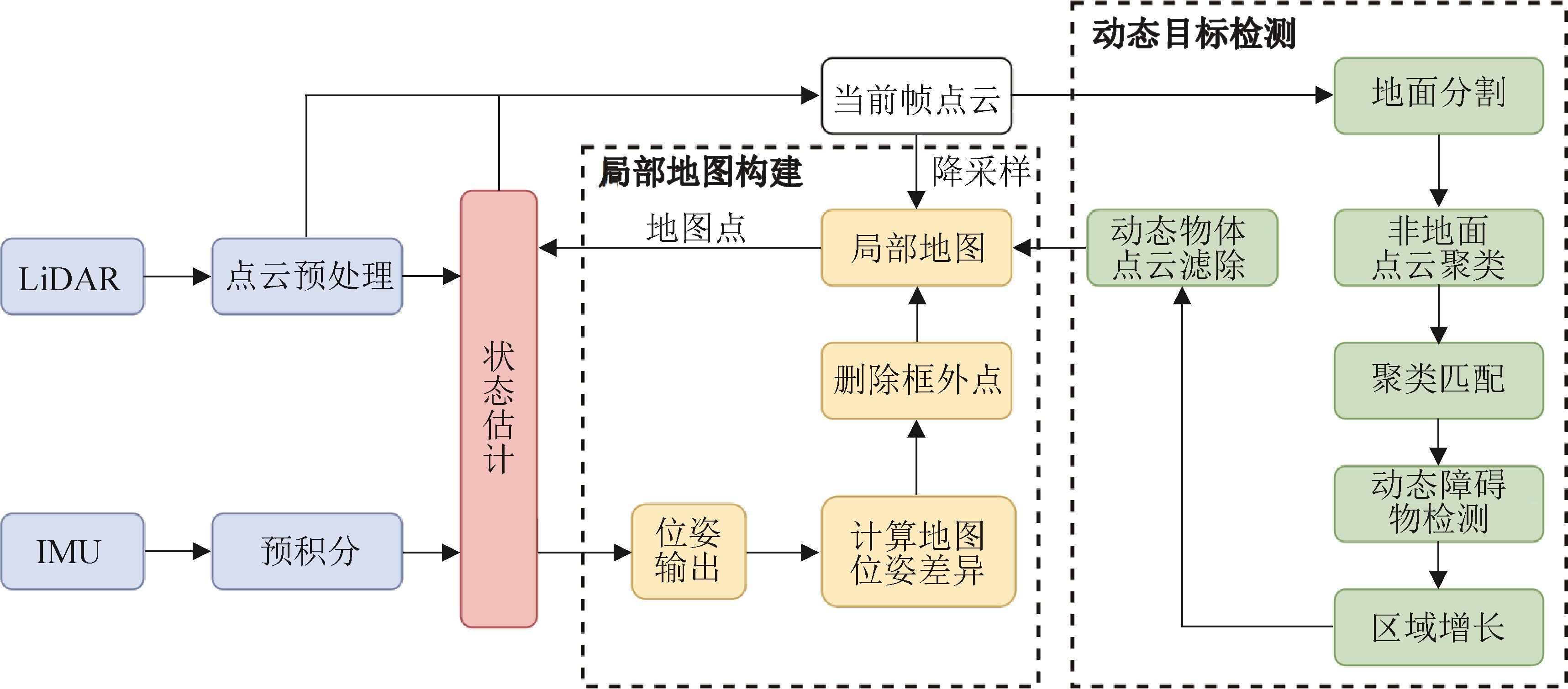
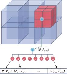
Fig. 2
Octree structure diagram
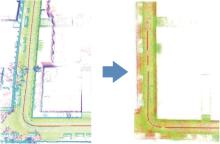
Fig. 3
Illustration of ground point cloud segmentation
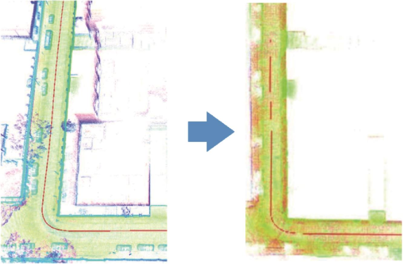
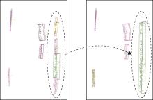
Fig. 4
Illustration of clustering clusters splicing
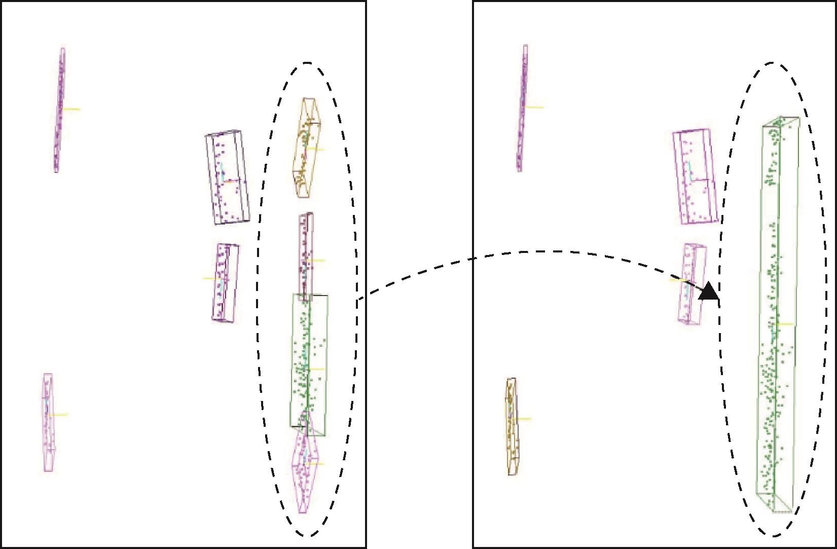

Fig. 5
Illustration of the poses of clusters at different times
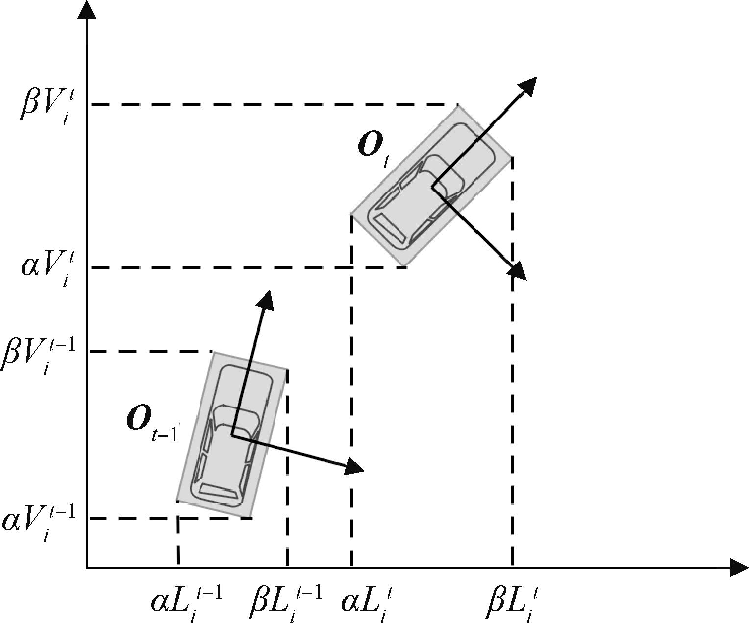
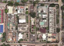
Fig. 6
HK-Data20190117 road condition diagram

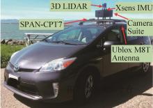
Fig. 7
Data collection platform
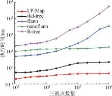
Fig. 8
Comparison of insertion efficiency of different structures
Fig. 9
Comparison of nearest neighbor search efficiency of different structures
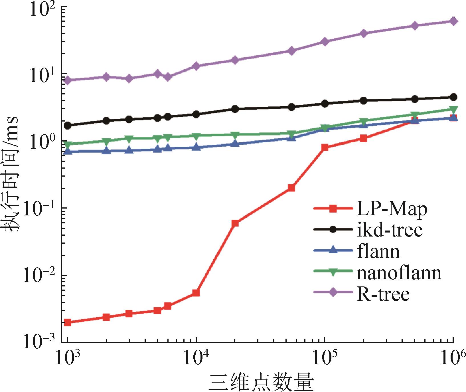
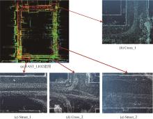
Fig. 10
FAST-LIO2 mapping and experimental data selection
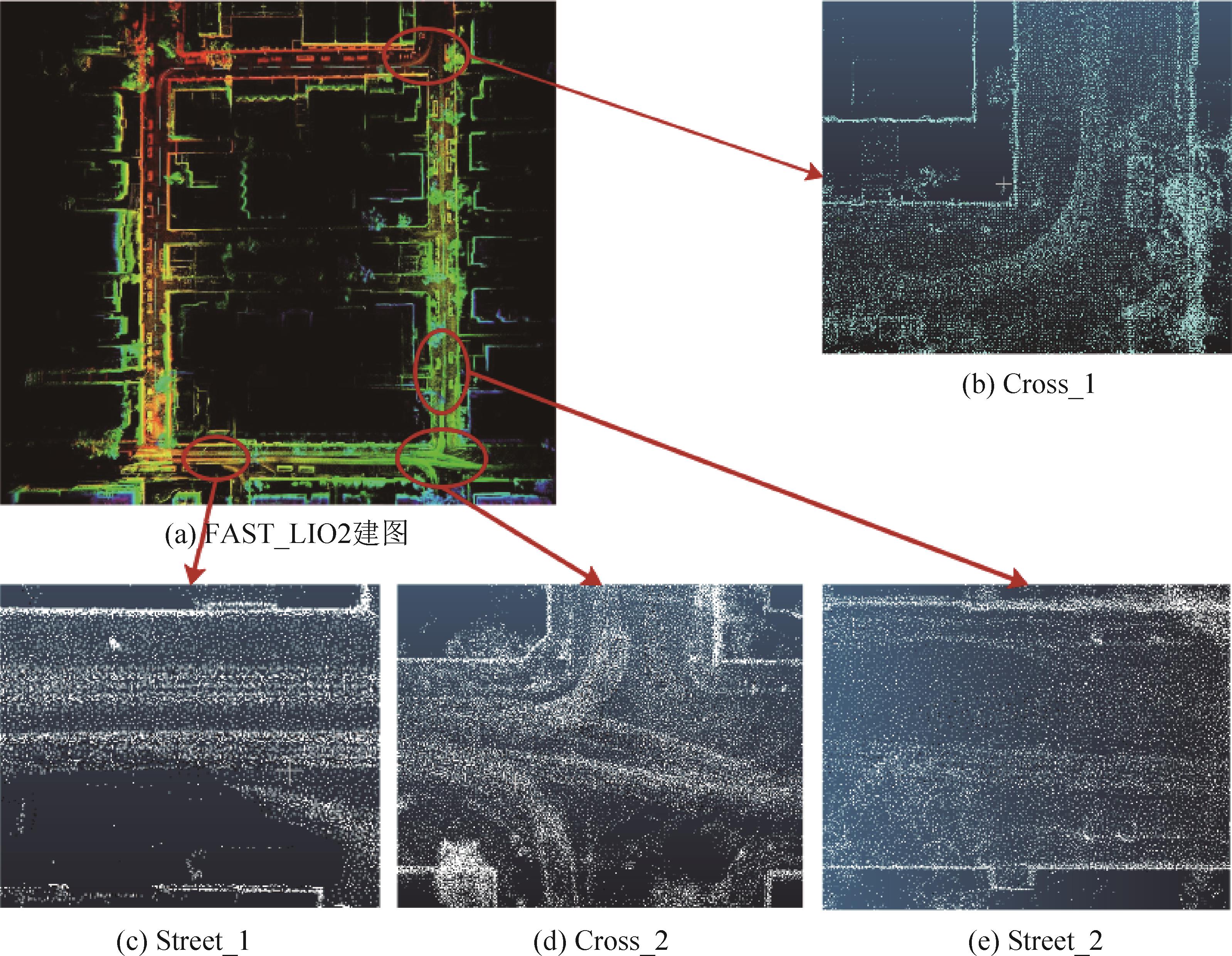
Table 1
Dataset sequence information
| 数据集序列 | 帧数 | 时间/s | 动态等级 |
|---|---|---|---|
| Street_1 | 248 | 25 | 高 |
| Street_2 | 284 | 28 | 高 |
| Cross_1 | 392 | 40 | 低 |
| Cross_2 | 357 | 35 | 低 |
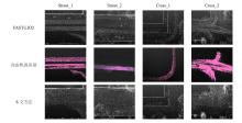
Fig. 11
Visualization of dynamic target elimination in four scenarios
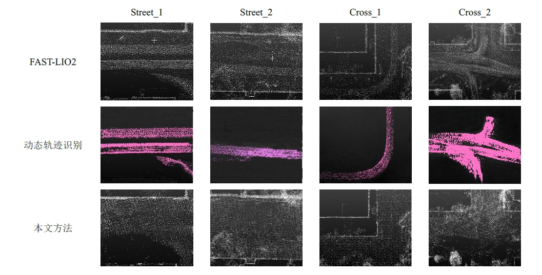
Table 2
Comparison experiment results of precision and recall of dynamic object culling
| 序列 | 动态程度 | Method | TP | FN | FP | R | P | Runtime/iteration/s |
|---|---|---|---|---|---|---|---|---|
| Street_1 | Removert | 12 088 | 208 | 2 050 | 0.983 | 0.855 | 0.820 8 | |
| 高 | ERASOR | 11 968 | 356 | 764 | 0.971 | 0.940 | 0.141 2 | |
| Ours | 11 694 | 602 | 1 312 | 0.951 | 0.899 | 0.064 2 | ||
| Street_2 | Removert | 6 745 | 223 | 1 362 | 0.968 | 0.832 | 0.894 5 | |
| 高 | ERASOR | 6 658 | 277 | 934 | 0.960 | 0.877 | 0.165 2 | |
| Ours | 6 542 | 244 | 1 056 | 0.964 | 0.861 | 0.076 1 | ||
| Cross_1 | Removert | 5 548 | 529 | 1 217 | 0.913 | 0.820 | 0.604 3 | |
| 低 | ERASOR | 5 614 | 475 | 582 | 0.922 | 0.906 | 0.095 4 | |
| Ours | 5 726 | 387 | 542 | 0.937 | 0.914 | 0.031 3 | ||
| Cross_2 | Removert | 15 968 | 2 198 | 2 136 | 0.879 | 0.882 | 0.746 1 | |
| 低 | ERASOR | 16 394 | 650 | 2 214 | 0.933 | 0.881 | 0.104 6 | |
| Ours | 16 744 | 1 030 | 1 798 | 0.942 | 0.903 | 0.054 7 | ||
| Removert | 3 671 | 145 | 643 | 0.962 | 0.850 | 1.156 4 | ||
| Seq_01 | 高 | ERASOR | 3 726 | 159 | 743 | 0.959 | 0.834 | 0.218 6 |
| Ours | 4 027 | 224 | 685 | 0.947 | 0.865 | 0.086 4 | ||
| Removert | 8 613 | 634 | 937 | 0.931 | 0.902 | 0.864 4 | ||
| Seq_02 | 低 | ERASOR | 8 264 | 603 | 863 | 0.932 | 0.905 | 0.154 6 |
| Ours | 8 936 | 537 | 738 | 0.943 | 0.924 | 0.071 5 | ||
| Removert | 14 273 | 1 902 | 1 836 | 0.882 | 0.886 | 0.785 2 | ||
| Seq_03 | 高 | ERASOR | 14 382 | 1 003 | 1 761 | 0.935 | 0.891 | 0.135 4 |
| Ours | 14 532 | 1 382 | 1 627 | 0.913 | 0.899 | 0.046 4 |
| 1 | 李凯, 王智宇, 奚瑞轩, 等. L4级自动驾驶汽车发展综述[J]. 专用汽车, 2023(2): 4-7. |
| 2 | Alif Ridzuan Khairuddin, Mohamad Shukor Talib, Haron Habibollah. Review on Simultaneous Localization and Mapping (SLAM)[C]//2015 IEEE International Conference on Control System, Computing and Engineering (ICCSCE). Piscataway: IEEE, 2015: 85-90. |
| 3 | 高翔, 张涛, 刘毅, 等. 视觉SLAM十四讲[M]. 北京: 电子工业出版社, 2017: 1-2. |
| 4 | Tao Chongben, Gao Zhen, Yan Jinli, et al. Indoor 3D Semantic Robot VSLAM Based on Mask Regional Convolutional Neural Network[J]. IEEE Access, 2020, 8: 52906-52916. |
| 5 | Mur-Artal Raúl, Montiel J M M, Tardós Juan D. ORB-SLAM: A Versatile and Accurate Monocular SLAM System[J]. IEEE Transactions on Robotics, 2015, 31(5): 1147-1163. |
| 6 | Wang Xi, Christie Marc, Marchand Eric. TT-SLAM: Dense Monocular SLAM for Planar Environments[C]//2021 IEEE International Conference on Robotics and Automation (ICRA). Piscataway: IEEE, 2021: 11690-11696. |
| 7 | 林士琪, 王纪凯, 裴浩渊, 等. 基于物体关系描述的单目语义SLAM方法[J]. 系统仿真学报, 2022, 34(2): 278-284. |
| Lin Shiqi, Wang Jikai, Pei Haoyuan, et al. Monocular Semantic SLAM Method Based on Object Relation Description[J]. Journal of System Simulation, 2022, 34(2): 278-284. | |
| 8 | 李维刚, 钟正, 王永强, 等. 基于时间距离-熵减策略的同步定位与地图构建算法[J]. 信息与控制, 2023, 52(5): 660-668, 688. |
| Li Weigang, Zhong Zheng, Wang Yongqiang, et al. Synchronous Localization and Mapping Algorithm Based on Time Distance-entropy Reduction Strategy[J]. Information and Control, 2023, 52(5): 660-668, 688. | |
| 9 | 焦嵩鸣, 姚鑫, 丁辉, 等. 适应于环境空间变化的激光雷达SLAM建图方法[J]. 系统仿真学报, 2023, 35(8): 1788-1798. |
| Jiao Songming, Yao Xin, Ding Hui, et al. Lidar SLAM Mapping Method Adapted to Environmental Spatial Changes[J]. Journal of System Simulation, 2023, 35(8): 1788-1798. | |
| 10 | Shan Tixiao, Englot B. LeGO-LOAM: Lightweight and Ground-optimized Lidar Odometry and Mapping on Variable Terrain[C]//2018 IEEE/RSJ International Conference on Intelligent Robots and Systems (IROS). Piscataway: IEEE, 2018: 4758-4765. |
| 11 | Shan Tixiao, Englot B, Meyers D, et al. LIO-SAM: Tightly-coupled Lidar Inertial Odometry via Smoothing and Mapping[C]//2020 IEEE/RSJ International Conference on Intelligent Robots and Systems (IROS). Piscataway: IEEE, 2020: 5135-5142. |
| 12 | Xu Wei, Cai Yixi, He Dongjiao, et al. FAST-LIO2: Fast Direct LiDAR-inertial Odometry[J]. IEEE Transactions on Robotics, 2022, 38(4): 2053-2073. |
| 13 | 方娟, 方振虎. 基于目标检测网络的动态场景下视觉SLAM优化[J]. 北京工业大学学报, 2022, 48(5): 466-475. |
| Fang Juan, Fang Zhenhu. Vision SLAM Optimization in Dynamic Scene Based on Object Detection Network[J]. Journal of Beijing University of Technology, 2022, 48(5): 466-475. | |
| 14 | Yu Chao, Liu Zuxin, Liu Xinjun, et al. DS-SLAM: A Semantic Visual SLAM towards Dynamic Environments[C]//2018 IEEE/RSJ International Conference on Intelligent Robots and Systems (IROS). Piscataway: IEEE, 2018: 1168-1174. |
| 15 | Lim Hyungtae, Hwang Sungwon, Myung Hyun. ERASOR: Egocentric Ratio of Pseudo Occupancy-based Dynamic Object Removal for Static 3D Point Cloud Map Building[J]. IEEE Robotics and Automation Letters, 2021, 6(2): 2272-2279. |
| 16 | Qian Chenglong, Xiang Zhaohong, Wu Zhuoran, et al. RF-LIO: Removal-first Tightly-coupled Lidar Inertial Odometry in High Dynamic Environments[C]//2021 IEEE/RSJ International Conference on Intelligent Robots and Systems (IROS). Piscataway: IEEE, 2021: 4421-4428. |
| 17 | 左勇, 任阳, 杜志华, 等. 基于LP-RANSAC算法的路面点云快速移除算法[J]. 激光与光电子学进展, 2023, 60(14): 376-381. |
| Zuo Yong, Ren Yang, Du Zhihua, et al. Rapid Removal Algorithm of Road Surface Point Cloud Based on LP-RANSAC Algorithm[J]. Laser & Optoelectronics Progress, 2023, 60(14): 376-381. | |
| 18 | Cao Yu, Wang Yancheng, Xue Yifei, et al. FEC: Fast Euclidean Clustering for Point Cloud Segmentation[J]. Drones, 2022, 6(11): 325. |
| 19 | 章勤, 黄琨, 李光明. 一种基于OBB的碰撞检测算法的改进[J]. 华中科技大学学报(自然科学版), 2003, 31(1): 46-48. |
| Zhang Qin, Huang Kun, Li Guangming. Improvement of Collision-detection Algorithm Based on OBB[J]. Journal of Huazhong University of Science and Technology(Natural Science Edition), 2003, 31(1): 46-48. | |
| 20 | Moosmann Frank, Pink Oliver, Stiller Christoph. Segmentation of 3D Lidar Data in Non-flat Urban Environments Using a Local Convexity Criterion[C]//2009 IEEE Intelligent Vehicles Symposium. Piscataway: IEEE, 2009: 215-220. |
| 21 | Fu Cong, Xiang Chao, Wang Changxu, et al. Fast Approximate Nearest Neighbor Search with the Navigating Spreading-out Graph[J]. Proceedings of the VLDB Endowment, 2019, 12(5): 461-474. |
| 22 | Guttman A. R-trees: A Dynamic Index Structure for Spatial Searching[J]. ACM SIGMOD Record, 1984, 14(2): 47-57. |
| 23 | Kim Giseop, Kim Ayoung. Remove, then Revert: Static Point Cloud Map Construction Using Multiresolution Range Images[C]//2020 IEEE/RSJ International Conference on Intelligent Robots and Systems (IROS). Piscataway: IEEE, 2020: 10758-10765. |
| [1] | Dong Zhiming, Hu Zhongqi, Dai Haoran, Gao Jiancheng. An Automated Generation Method for Combat Simulation Scenarios Based on Large Language Models [J]. Journal of System Simulation, 2026, 38(5): 1129-1145. |
| [2] | Peng Yi, Wang Jun, Yang Qingqing, Wang Jianming, Li Hui. Robust Two-stage MIMO-OFDM Channel Estimation Method Against Sensing Errors [J]. Journal of System Simulation, 2026, 38(5): 1205-1223. |
| [3] | Zhou Zicong, Zeng Junjie, Hu Yue, Zhu Zhengqiu, Yin Quanjun. Multi-agent Reinforcement Learning Method for Wargame Simulation Based on Suboptimal Demonstration Guidance [J]. Journal of System Simulation, 2026, 38(5): 1277-1289. |
| [4] | Zhang Xin, Zhang Ping, Zhang Chen, Liu Wei, Han Boyang. Research on Calculation Model of Excavation Resistance Under Heterogeneous Soil Conditions [J]. Journal of System Simulation, 2026, 38(5): 1320-1332. |
| [5] | Teng Jing, Tong Wencong, Zhang Zhongjie, Yao Xing, Li Junxian. Automatic Speed Guidance Method and Simulation Evaluation for Trams at Intersections [J]. Journal of System Simulation, 2026, 38(5): 1426-1439. |
| [6] | Sun Xiaozhe, Fu Zhenyu, Xu Zhaoke, Li Jianxin. Mechanism Analysis of Parasitic Torque in Electric Loading Systems [J]. Journal of System Simulation, 2026, 38(4): 1018-1029. |
| [7] | Lang Xianwei, Wang Yantao, Zhang Fang, Zu Yizhen, Zhang Xinyu, Xiang Weibin. Simulation on Water Hammer Characteristics of Bipropellant Attitude and Orbit Control Propulsion System [J]. Journal of System Simulation, 2026, 38(4): 1046-1057. |
| [8] | Yan Dong, Yang Hanzhe, Jiang Fangfang, Liu Chengbao, Zhang Peng. Design and Application of Collaborative Simulation System for Satellite Constellation Flight Missions [J]. Journal of System Simulation, 2026, 38(4): 1067-1079. |
| [9] | Li Wenlong, Sang Shuhan, Liu Yusheng, He Haiyan, Liang Zan, Yuan Wenqiang, Niu Biao, Luo Weifeng. Dynamic Model-driven Verification Framework for Modular Aerial Bomb Systems [J]. Journal of System Simulation, 2026, 38(4): 1106-1118. |
| [10] | Sun Bo, Ren Yi, Wang Silin, Liu Qi, Li Zhidong. Model-based System Verification: Theoretical Framework, Key Technologies, and Future Prospects [J]. Journal of System Simulation, 2026, 38(4): 829-854. |
| [11] | Peng Laichunyang, Ye Fei, Guo Xiaoming, Zhou Jinglin. Large Language Model for X Language Simulation: Architecture, Key Technologies, and Typical Applications [J]. Journal of System Simulation, 2026, 38(4): 869-888. |
| [12] | Wei Juhui, Zhang Xinyong, Wang Jiongqi, Zhou Xuanying, He Zhangming. Space-ground Integrated Collaborative Positioning Algorithm and Simulation for Trajectory Enhancement [J]. Journal of System Simulation, 2026, 38(4): 916-931. |
| [13] | Li Zhicheng, Liu Shuaijun, Liu Lixiang. Research on Inter-satellite Topology Design and Simulation of Giant LEO Constellation Network with Consistent Pattern [J]. Journal of System Simulation, 2026, 38(3): 687-701. |
| [14] | Wang Xueqian, Men Jianbing, Zhou Xin, Wang Shuyou, Li Mei. A Precise Damage Assessment Method for Lethal Blast Warheads Against Quadruped Robots [J]. Journal of System Simulation, 2026, 38(3): 702-713. |
| [15] | Feng Xuejian, Ding Han, Tong Yiqi, Huo Chaoying, Zhang Yanjin. Simulation and Multi-perspective Recognition Algorithm for Typical Trajectory Shapes [J]. Journal of System Simulation, 2026, 38(3): 725-735. |
| Viewed | ||||||
|
Full text |
|
|||||
|
Abstract |
|
|||||
