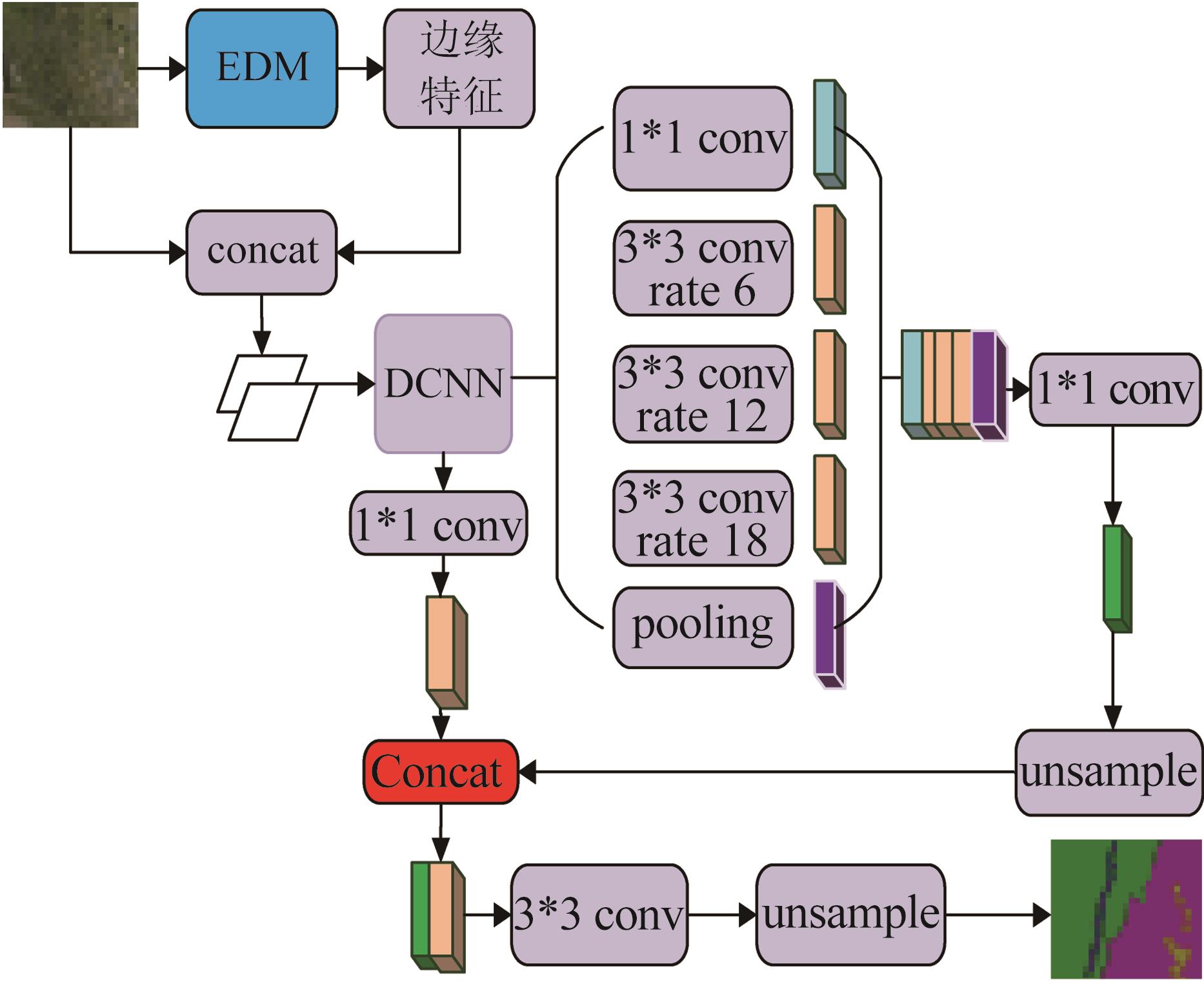
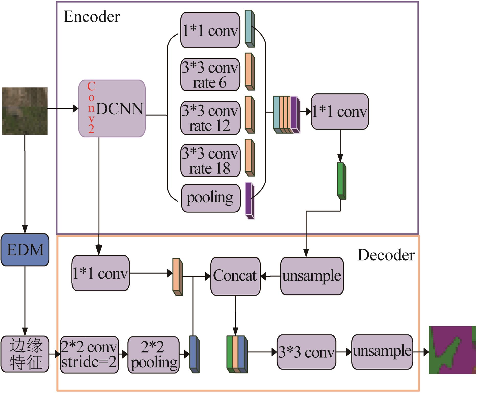
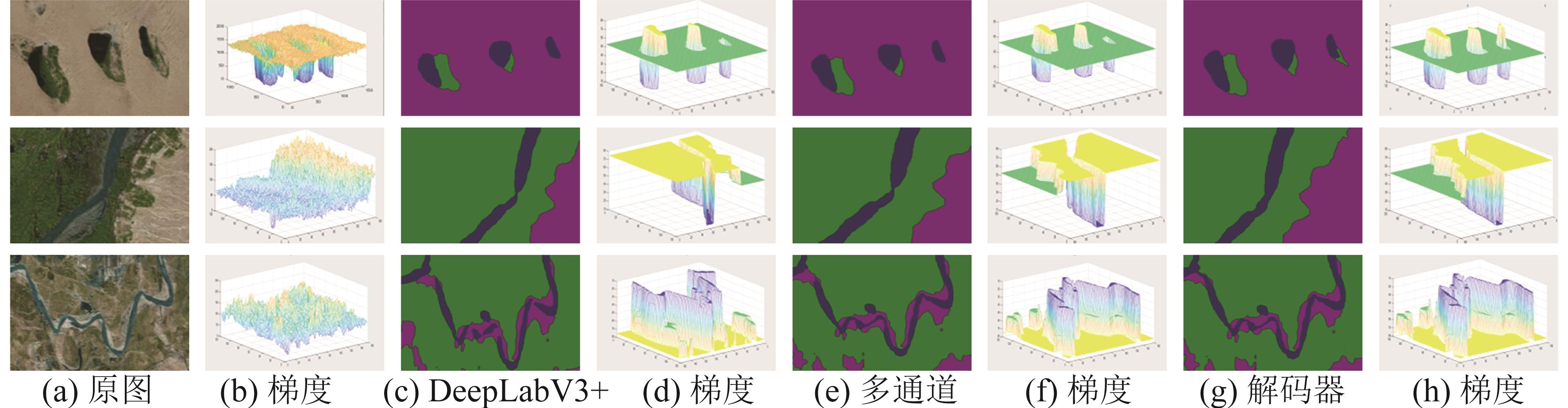
| 1 |
Badrinarayanan V, Kendall A, Cipolla R. SegNet: A Deep Convolutional Encoder-Decoder Architecture for Scene Segmentation[J]. IEEE Transactions on Pattern Analysis & Machine Intelligence(S0162-8828), 2017, 39(12) 2481-2495.
|
| 2 |
Lin G, Milan A, Shen C, et al. RefineNet: Multi-path Refinement Networks for High-Resolution Semantic Segmentation[C]// IEEE Conference on Computer Vision and Pattern Recognition. IEEE Computer Society, 2017:5168-5177.
|
| 3 |
Liu Z, Li X, Ping L, et al. Deep Learning Markov Random Field for Semantic Segmentation[J]. IEEE Trans Pattern Anal Mach Intell(S0162-8828), 2018: 1814-1828.
|
| 4 |
陈聪. 基于深层网络的城市街道场景的语义分割的方法研究[D]. 西安: 西安电子科技大学, 2019.
|
|
Chen Cong.Reserch on Semantic Segmentation of Cityscape Based on Deep Neural Network[D].Xi′an Xidian University, 2019.
|
| 5 |
Long J, Shelhamer E, Darrell T. Fully Convolutional Networks for Semantic Segmentation[J]. IEEE Transactions on Pattern Analysis & Machine Intelligence(S0162-8828), 2014, 39(4): 640-651.
|
| 6 |
林志洁, 罗壮, 赵磊, 等.特征金字塔多尺度全卷积目标检测算法[J].浙江大学学报(工学版), 2019, 53(3): 533-540.
|
|
Lin Zhijie, Luo Zhuang, Zhao Lei, et al. Multi-scale Full Convolution Target Detection Algorithm for Feature Pyramid [J]. Journal of Zhejiang University (Engineering Edition), 2019, 53(3): 533-540.
|
| 7 |
Wu Dihua,Yin Xuqiang,Jiang Bo,et al. Detection of the Respiratory Rate of Standing Cows by Combining the Deeplab V3+ Semantic Segmentation Model with the Phase-based Video Magnification algorithm[J]. Biosystems Engineering(S1615-7591), 2020: 72-89.
|
| 8 |
Chen L C, Papandreou G, Kokkinos I, et al. Deeplab: Semantic Image Segmentation with Deep Convolutional Nets, Atrous Convolution, and Fully Connected Crfs[J]. IEEE Transactions on Pattern Analysis and Machine Intelligence(S0162-8828), 2018, 40(4): 834-848.
|
| 9 |
Tang Wei,Zou Dongsheng,Yang Su,et al. A Two-stage Approach for Automatic Liver Segmentation with Faster R-CNN and DeepLab[J]. Neural Computing and Applications(S0941-0643), 2020, 32(11): 6769-6778.
|
| 10 |
Wu Dihua,Yin Xuqiang,Jiang Bo,et al. Detection of the Respiratory Rate of Standing Cows by Combining the Deeplab V3+ Semantic Segmentation Model with the Phase-based Video Magnification Algorithm[J]. Biosystems Engineering(S1537-5110), 2020: 72-89.
|
| 11 |
Zhao H, Shi J, Qi X, et al. Pyramid Scene Parsing Network[C]// Proceedings of the IEEE Conference on Computer Vision and Pattern Recognition, 2017: 2881-2890.
|
| 12 |
Lin G, Milan A, Shen C, et al. Refinenet: Multi-path Refinement Networks for High-resolution Semantic Segmentation[C]// Proceedings of the IEEE Conference on Computer Vision and Pattern Recognition, 2017: 1925-1934.
|
| 13 |
Xu Wang,Chen Renwen,Huang Bin,et al. Single Image Super-Resolution Based on Global Dense Feature Fusion Convolutional Network[J]. Sensors(S1424-8220), 2019, 19(2): 316-335.
|
| 14 |
Liu Z, Li X, Ping L, et al. Deep Learning Markov Random Field for Semantic Segmentation[J]. IEEE Transactions on Pattern Analysis and Machine Intelligence(S0162-8828), 2018, 40(8): 1418-1428.
|
| 15 |
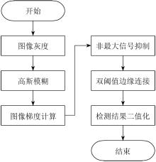
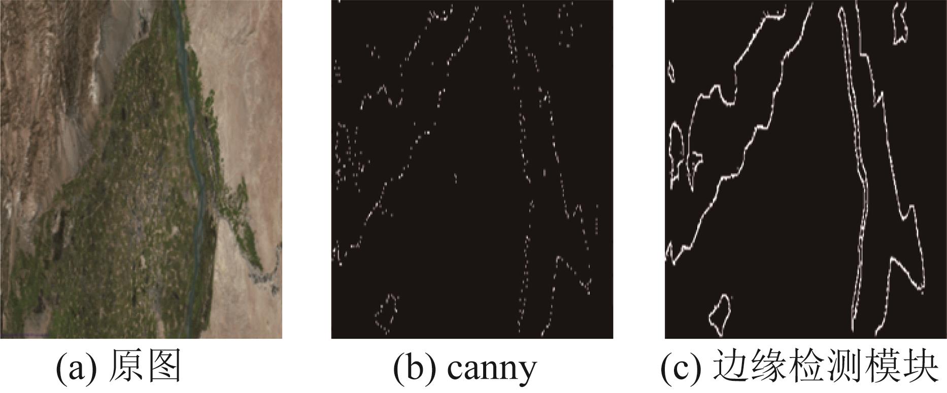
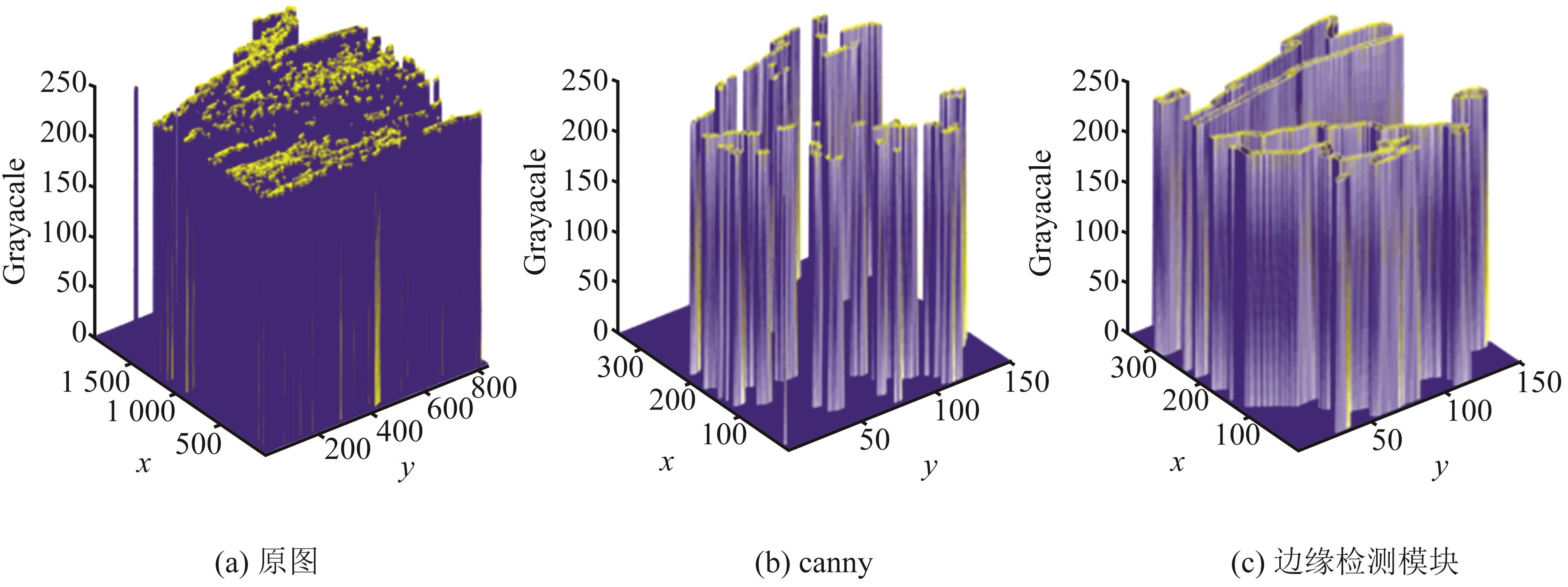
Zhang Xiao, Chen Fuen. Lane Line Edge Detection Based on Improved Adaptive Canny Algorithm[J]. Journal of Physics: Conference Series(S1742-6588), 2020, 1549(2): 1362-1375.
|
 ), 高春艳